Location: Stowe, Maine
Difficulty: Moderate
Total Distance: 7.8 Miles
Total Time: 4.5 Hours
Average Time: 5.5 Hours
Date: July 21st, 2013
GPS Route: Mapmyrun.com
Introduction
The loop that we chose to hike is located in western Maine, along Rt. 113, south of Evan's Notch. Our hike was 7.81 miles long, had a total ascent of 1,919 ft, and a maximum elevation of 2,664 ft. Along the way there are lots of lookout points and side trails with fantastic views, we chose to take one side trail along Blueberry Mountain, which added 0.4 miles, but was well worth the trip for the views and the delicious wild blueberries. We skipped the 0.5 mile side trail that summits Speckled Mountain, because the focus of our trip was to collect blueberries!
We chose to hike this loop in a counter-clockwise direction, by heading up Blueberry Mountain via the Blueberry Ridge Trail first, then along Blueberry Ridge to Ames Mountain, where we followed the Bickford Brook Trail back to the parking lot. I've hiked these trails in both directions, and have found that hiking the loop in a clockwise direction is much easier, as the ascent along the Bickford Ridge Trail is much more gradual, than the ascent up the Blueberry Ridge Trail. So if you prefer a more gradual incline, its best to hike this loop in a clockwise direction.
Evan's Notch
Just 30 minutes north of Fryeburg, Maine, along Rt. 113, is Evan's Notch; one of my favorite places to go hiking. It's easy to access in the summer months, and its proximity to Portland, Maine makes Evan's Notch a great destination for day hikes. The scenic drive along Rt. 113 crosses back and forth along the Maine-New Hampshire border, through beautiful farmland at the foot of the mountains. Be sure to check out the local farm stands for a wide variety of local produce, dairy and meats.
The hikes in this area range from short to long, and from gradual to steep. On the west side of Rt. 113 is the Baldface-Royce mountain range, with its steep climbs and exposed rock slaps, it's a great area for seasoned hikers looking for longer hikes, along steeper terrain. On the east side of Rt. 113 is the Caribou-Speckled mountain wilderness, with more gradual terrain and shorter distances, this area is wonderful for beginner to intermediate hikers and has many very short hikes that are great for kids.
As with every hike, be sure to bring plenty of water and food for your trip, also carry extra clothing in the event of bad weather. This area receives lots of flash floods, and if you're not prepared for poor conditions, it could be very dangerous and life threatening. Streams in this area can rise dramatically with heavy rain, so check the weather forecast before leaving, and pay attention to threatening clouds. When in doubt, turn around!
Directions to Trailhead
From Fryeburg, Maine, turn right onto Rt. 113 North and stay on Rt. 113 for 19.7 miles. There are many turns along the way, so pay attention to the road signs and stay on Rt. 113. Along the way you'll enter into the White Mountain National Forest, while crossing along the ME - NH borders a couple of times. Eventually the road will narrow and will no longer have a shoulder, so be aware of bicyclists and motorcycles, as this road is frequently traveled during the summer. Just before the trailhead parking lot, you'll see signs for Basin campground on the left. Immediately after the campground entrance, there will be a sign for Brickett Place on the right.
Take a right into the Brickett Place parking lot, there you'll see the 19th century brick farmhouse on the left and as you pull into the dirt parking lot, you'll notice the trailhead billboard located on the right. Toilets are located to the right of the farmhouse. When the Brickett house is open, there will be a volunteer tending to the house and assisting visitors with information on hiking and camping areas. There is a small fee for day use parking, instructions are located on the trailhead billboard, it was $3/car when we were there. Please read the billboard for any notices in the area, such as forest fire prevention, trail conservation and bear sightings.
Summary
The mosquitos and black flies were out with vengeance that day, hence our quick pace right from the start. Even though we applied plenty of bug repellant, we were definitely eaten alive in the first 30-40 mins of the hike. Once we gained some elevation (and the trail ascended quickly), there was a nice breeze which helped clear away the bugs, and cooled us off. A few miles further into the hike we noticed a full size garter snake curled up on the trail collecting sun.
As we continued along we reached the beginning of the blueberry bushes that lined the trail for a couple of miles. We were fortunate enough to collect a lot of early season blueberries along the way, which later Kristin made into amazing wild blueberry muffins. Please be aware that many plants in alpine areas are very fragile and are easily destroyed when stepped on, so please stay on the marked trails.
We took many breaks during the climb from Blueberry Mountain to Ames Mountain. The ridge was a great place to stop, check out the views, and gather more energy for the ascent to Ames Mountain. By this point the cool breeze eliminated all of the bugs, and allowed us to slow our pace to a more appropriate speed to the trail junction west of Ames Mountain.
Once we started our descent, the gentle terrain allowed us to pick up our pace and enjoy the sounds of nature around us. With every step the surrounding forests slowly changed from an alpine terrain back to a mixed-wood forest. A few miles from the end, our trail connected with Bickford Brook and with it the bugs returned, but this time not nearly as hungry. As we continued along we came across a couple patches of fresh chanterelle mushrooms, and even noticed a few baby black trumpet mushrooms.
Soon the trail leveled out again as we reached the Brickett Place parking lot where we began. It was a great hike, with many wonderful views, lots of wildlife and tons of blueberries. On our way home, we stopped at a local farmstand and were able to purchase local produce and meats. Definitely a great day in the mountains!
If you're considering hiking this loop for the first time, I would highly recommend hiking the loop in the opposite direction (clockwise). As you can see in the elevation gain chart above, the ascent up Blueberry Mountain is steep in sections and can be exhausting, especially in hot weather.
If you like steep climbs up mountains, and along ridge lines, follow the route that we took (counter-clockwise).
 |
| Evan's Notch Along Rt. 113 |
Just 30 minutes north of Fryeburg, Maine, along Rt. 113, is Evan's Notch; one of my favorite places to go hiking. It's easy to access in the summer months, and its proximity to Portland, Maine makes Evan's Notch a great destination for day hikes. The scenic drive along Rt. 113 crosses back and forth along the Maine-New Hampshire border, through beautiful farmland at the foot of the mountains. Be sure to check out the local farm stands for a wide variety of local produce, dairy and meats.
The hikes in this area range from short to long, and from gradual to steep. On the west side of Rt. 113 is the Baldface-Royce mountain range, with its steep climbs and exposed rock slaps, it's a great area for seasoned hikers looking for longer hikes, along steeper terrain. On the east side of Rt. 113 is the Caribou-Speckled mountain wilderness, with more gradual terrain and shorter distances, this area is wonderful for beginner to intermediate hikers and has many very short hikes that are great for kids.
As with every hike, be sure to bring plenty of water and food for your trip, also carry extra clothing in the event of bad weather. This area receives lots of flash floods, and if you're not prepared for poor conditions, it could be very dangerous and life threatening. Streams in this area can rise dramatically with heavy rain, so check the weather forecast before leaving, and pay attention to threatening clouds. When in doubt, turn around!
Directions to Trailhead
From Fryeburg, Maine, turn right onto Rt. 113 North and stay on Rt. 113 for 19.7 miles. There are many turns along the way, so pay attention to the road signs and stay on Rt. 113. Along the way you'll enter into the White Mountain National Forest, while crossing along the ME - NH borders a couple of times. Eventually the road will narrow and will no longer have a shoulder, so be aware of bicyclists and motorcycles, as this road is frequently traveled during the summer. Just before the trailhead parking lot, you'll see signs for Basin campground on the left. Immediately after the campground entrance, there will be a sign for Brickett Place on the right.
Take a right into the Brickett Place parking lot, there you'll see the 19th century brick farmhouse on the left and as you pull into the dirt parking lot, you'll notice the trailhead billboard located on the right. Toilets are located to the right of the farmhouse. When the Brickett house is open, there will be a volunteer tending to the house and assisting visitors with information on hiking and camping areas. There is a small fee for day use parking, instructions are located on the trailhead billboard, it was $3/car when we were there. Please read the billboard for any notices in the area, such as forest fire prevention, trail conservation and bear sightings.
.jpg) |
| Green pin indicated Brickett Place parking and trailhead |
Our Hike
We started from the Brickett Place parking lot and hiked east for 0.7 miles along Bickford Brook Trail until we reached our first trail junction. From there we followed the Blueberry Ridge Trail southeast for another 0.7 miles. Soon after the first junction, the trail crossed Bickford Brook and shortly after we came across the trail junction for the Bickford Slides Loop, however we continued along the BR Trail towards Blueberry Mountain. At this point the trail started it's steep and strenuous ascent to the summit.
 |
| Kristin & Maggie |
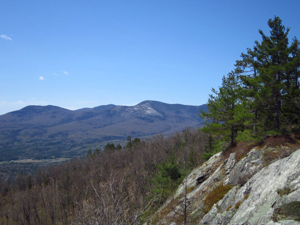
Just shy of the Blueberry Mountain summit we followed a short side trail south, which opened up into beautiful southern views of the valley below, displaying the town of Fryeburg and the surrounding white mountains. Looking due south, we were able to see Little Deer and Deer Hills, to the west we could see the rocky slabs of south baldface, and looking southwest we could see Kearsarge North and Mt. Chocorua. The side trail eventually leads east and then north to the summit of Blueberry Mountain, where we continued to pick blueberries along the way.
After reaching the summit, we followed the gradual incline of the Blueberry Ridge Trail north/northeast for 2.2 miles, along the way were beautiful moss covered granite slabs, with wonderful views in all directions. As we hiked closer to Ames Mountain, the trail became steeper with an average incline of 8.5%. Eventually we reached the junction with the Bickford Brook Trail. From there we decided to head west along the BB Trail towards Ames Mountain. The trail continued west for 0.7 miles until we reached the next junction, where the Spruce Hill Trail intersects. We stayed on the BB Trail south/southwest for 2.4 miles, gradually descending back to the original junction of BR Trail and BB Trail. Once we reached the junction it was a familiar 0.7 mile hike back to our car.
 |
| Elevation Gain Over Distance |
.jpg) |
| Pace vs. Elevation during our hike |
The mosquitos and black flies were out with vengeance that day, hence our quick pace right from the start. Even though we applied plenty of bug repellant, we were definitely eaten alive in the first 30-40 mins of the hike. Once we gained some elevation (and the trail ascended quickly), there was a nice breeze which helped clear away the bugs, and cooled us off. A few miles further into the hike we noticed a full size garter snake curled up on the trail collecting sun.
As we continued along we reached the beginning of the blueberry bushes that lined the trail for a couple of miles. We were fortunate enough to collect a lot of early season blueberries along the way, which later Kristin made into amazing wild blueberry muffins. Please be aware that many plants in alpine areas are very fragile and are easily destroyed when stepped on, so please stay on the marked trails.
We took many breaks during the climb from Blueberry Mountain to Ames Mountain. The ridge was a great place to stop, check out the views, and gather more energy for the ascent to Ames Mountain. By this point the cool breeze eliminated all of the bugs, and allowed us to slow our pace to a more appropriate speed to the trail junction west of Ames Mountain.
Once we started our descent, the gentle terrain allowed us to pick up our pace and enjoy the sounds of nature around us. With every step the surrounding forests slowly changed from an alpine terrain back to a mixed-wood forest. A few miles from the end, our trail connected with Bickford Brook and with it the bugs returned, but this time not nearly as hungry. As we continued along we came across a couple patches of fresh chanterelle mushrooms, and even noticed a few baby black trumpet mushrooms.
Soon the trail leveled out again as we reached the Brickett Place parking lot where we began. It was a great hike, with many wonderful views, lots of wildlife and tons of blueberries. On our way home, we stopped at a local farmstand and were able to purchase local produce and meats. Definitely a great day in the mountains!
If you're considering hiking this loop for the first time, I would highly recommend hiking the loop in the opposite direction (clockwise). As you can see in the elevation gain chart above, the ascent up Blueberry Mountain is steep in sections and can be exhausting, especially in hot weather.
If you like steep climbs up mountains, and along ridge lines, follow the route that we took (counter-clockwise).